How Does Infra Work?
by Vito Vitale and Guido Bernardi | Published: 01-Aug-24 | Last updated: 01-Aug-24 | Tags : ArcticService INFRA wildfire | category: NEWS
Arctic PASSION is developing a web mapping service for wildfires to make the access to relevant information and products easier from diverse sources. Focusing on a local scale, the Integrated Fire Risk Management (INFRA) Service for Arctic wildfires will provide the possibility to generate and distribute messages on wildfires that are tailored to non-scientific end-users like municipalities, as well as Indigenous Peoples and local communities.
INFRA is still under development, but we would like to provide insight into the technical solutions behind it and how it is all going to work.
THIS IS HOW WE DO IT
The INFRA service aims to simplify access to relevant information and products on wildfires, and make it possible to integrate and transform information thanks to its modularity.
The service is based on several modules and IT platforms, the most important being:
- INFRA-AEGIS: A web-GIS platform through which it is possible to present, combine, and integrate all the informational layers produced by INFRA or collected from other sources and services.
- INFRA-SENTRY: A platform through which to distribute information and messages to users. Messages can easily be handled and adapted to specific needs and generated following the Common Alerting Protocol (CAP) Standard.
INFRA modules are developed to be installed in a cloud computing service, increasing accessibility and flexibility of use. This also reduces the need for local hardware and software resources. In designing and developing INFRA functional blocks, we largely adopted a modularity strategy to cover a wide spectrum of specific needs oriented to the local and regional scale. This was considered necessary as local wildfire services are strongly related to the characteristics of the area they cover, as well as the users and stakeholders they serve.
Taking advantage of this modularity, a MULTI-LEVEL implementation strategy was considered when aligning the use of the INFRA service to user interests, capacities, and resources.
LEVEL ZERO: COLLECT, INTEGRATE, INTERPRET, TRANSFORM INFORMATION
The INFRA-AEGIS module can be easily accessed by individuals, as well as indigenous communities and small municipalities. Level zero has been implemented up to the operational mode and made accessible for three target areas in Sacha-Yakutia, Fennoscandia and Alaska, each of about 1500 x 1500 km. The computing cloud environment makes it easy to add other target areas on demand.
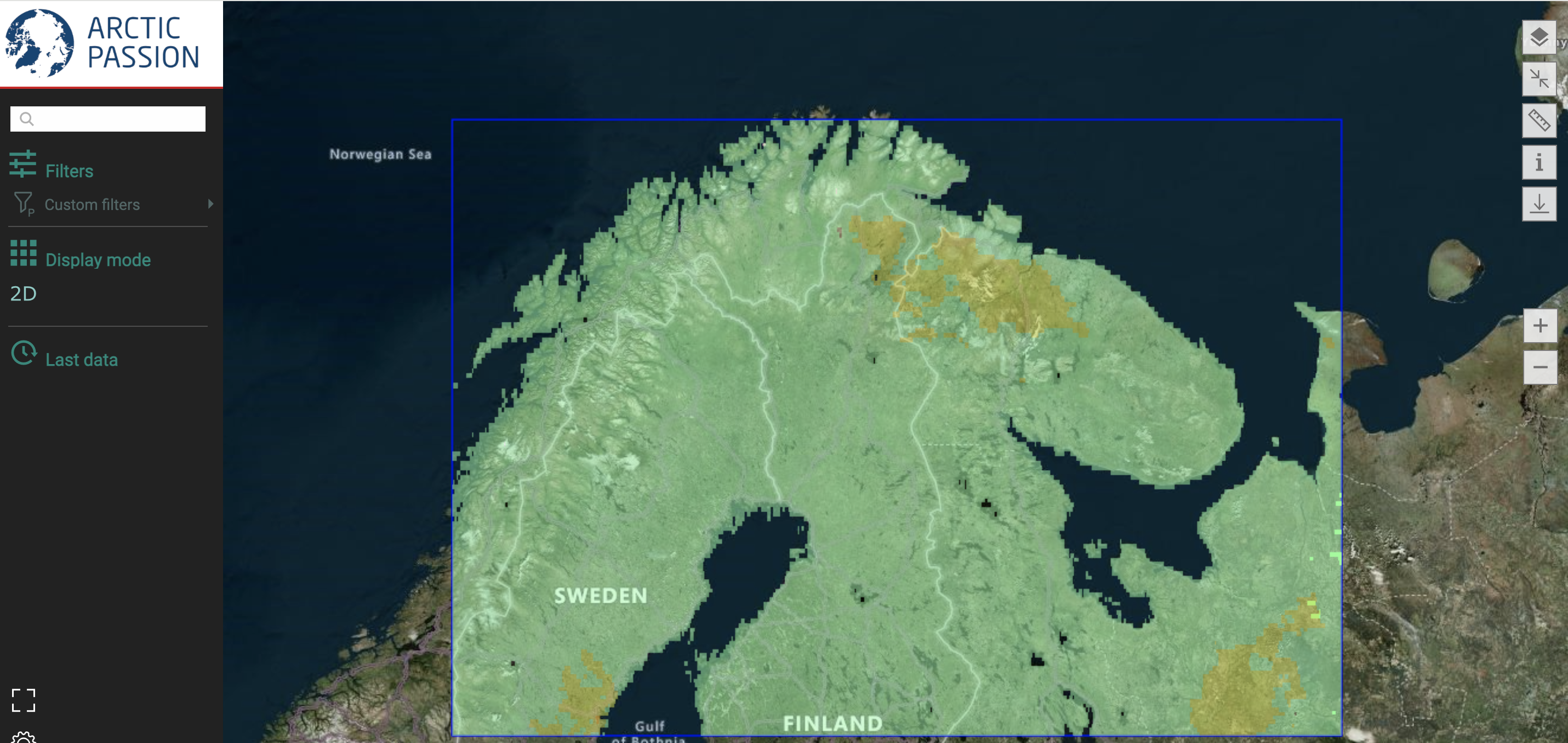
A screenshot of the INFRA target area in Fennoscandia.
Information layers currently available on the web-service are:
· RISK INDEX,
· IGNITION RISK (lightning),
· ACTIVE FIRES/BURNED AREAS, and
· FUEL MAP.
SITES OF INTEREST can also be included to focus on a local scale of 50x50 km.
Products and information are extracted by the Global Wildfire Information System (GWIS) a joint initiative of the GEO and the Copernicus Work Programs. The only exception being a fuel map evaluated on an annual basis from MODIS observations (500 m resolution) making use of a new fuel type mapping methodology.
LEVEL 1: PRODUCE AND DISSEMINATE TAILORED MESSAGES
The integration of INFRA-AEGIS and INFRA-SENTRY allows the production and distribution of tailored messages.
Steps and resources necessary are:
- Identify the area of interest;
- Collect information on target people to reach with messages and information;
- Define message formats, language, information to distribute. Information can be tailored for each user category;
- Identify/secure experts who will act as the key operators to acquire/integrate/select information through INFRA-AEGIS, transforming information into messages, and distributing them via INFRA-SENTRY functionalities;
- Set up a working space and resources for the operators to work.
“Experts” will have a simple mask to introduce information, write a text, and link images. The system will store them in CAP (Common Alerting Protocol) Standard. INFRA-SENTRY will manage and distribute messages across mediums and platforms (SMS, e-mail, phone calls, social media, to other computer/services, etc.) through specific plugins. Dissemination of information and alerts can be customised by defining contacts, groups of users, distribution profiles, and availability of each contact. It will be possible to order simple actions, such as automatically activating a relay.
LEVEL 2 and 3: METEO INFORMATION, ADDITIONAL RISK INDEXES, AND MORE
- Level 2A - Numerical weather prediction module (MOLOCH 1.3 km resolution) developed at CNR-ISAC is added, supplying 13 additional information layers to INFRA-AEGIS.
- Level 2B - in addition to NWP outputs, several risk indexes and other information parameters increase GIS information layers in INFRA-AEGIS.
- Level 3 - information on wildfires arising from ground observing systems (based on automatic instrumentation) and/or individual inhabitants/citizens can be also managed.
The levels 1-3 will be available in test mode and password protected for two target areas for selected experts. Additional information and material can be found on a dedicated webpage on the Italian Arctic Programme Portal that is by the time of writing this article under construction.
There is still a lot development and testing work ahead of us. We are also working on a webinar to illustrate the use of INFRA-AEGIS, so
MORE COMING SOON!
Photo by GRID-Arendal / Peter Prokosch