Finally, We Have The Technology To Observe Trends In Permafrost Landscape Change In The Arctic
by Sabrina Heerema | Published: 07-Feb-24 | Last updated: 07-Feb-24 | Tags : Alaska Arctic change climate Landscape map Pan-Arctic permafrost PilotService remote Remote Sensing | category: PRESS RELEASE
Introducing ALEX, the Arctic Landscape EXplorer: A new map tool for monitoring pan-Arctic trends of permafrost landscape change
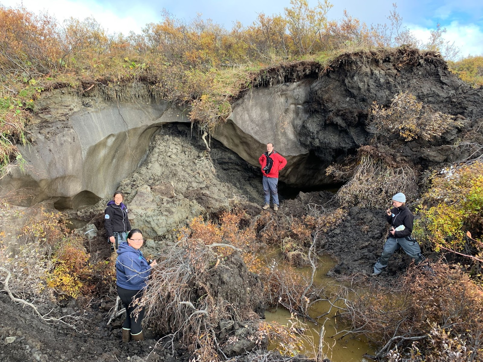
Tillmann Lübker (center) and a AWI-UAF team during field work to study permafrost disturbances near Kotzebue in West Alaska. Photo: Guido Grosse
Arendal, Norway / Potsdam, Germany - Permafrost (from ‘permanent’ and ‘frost’) is ground that continuously remains at or below 0° C for at least two consecutive years. Around 15% of the land surface in the Northern Hemisphere is underlain by permafrost, which often contains and preserves biomass accumulated throughout millennia and thus acts as a carbon sink. The amount of carbon stored in permafrost is four times the carbon that has been released to the atmosphere due to human activities in modern times. (Canadian Geographic, 2018) As frozen soil thaws, microbial decomposition of organic matter releases carbon dioxide or methane, greenhouse gases that contribute to global warming and further increase permafrost thawing at a global scale. Land surface changes associated with permafrost thaw include the acceleration of Arctic coastal erosion, increased thaw slumping in hillslope regions, the drainage and formation of lakes, as well as an intensification of disturbances on land, such as forest fires and droughts. Thermo-erosion leads to gullying, slumping, and even landslides and threatens infrastructure. Information on where these changes in permafrost stability occur in the Arctic and to what extent they are an important factor for the management of the land and infrastructure is scarce.
Many communities living in areas with permafrost have first-hand knowledge of local problems with erosion and thaw subsidence. However, until now Arctic communities have not been able to receive spatially explicit information on recent or ongoing thaw and erosion at broader scales providing vital information on how existing infrastructure or planned future infrastructure developments might be threatened. This information would be vital for better management, planning, decision-making, increased safety, and more targeted local responses in Arctic communities, but also to give scientists vital information about the development.
Arctic PASSION recently published the Arctic Landscape EXplorer (ALEX) (Figure 1), which contains data on satellite-derived trends in land surface changes at 30 meter resolution for the entire Arctic permafrost region for the 20 years from 2003 to 2022. The freely available online tool features an easy-to-use and well-explained map interface and was developed specifically for non-experts to meet the information needs of local Arctic communities living in areas with permafrost. It includes a localized view of the information provided and a storytelling component, and parts of the website will be available in multiple Arctic languages soon. Consultations with local representatives and stakeholders from Alaska aimed to ensure that their actual information needs are met.
“Dozens of lakes in Alaska have disappeared in recent years. This lake was used as a freshwater source for the village, forcing the community to find an alternative supply. This individual example shows us how communities living on frozen ground are directly affected by rapid changes in their lands.”
Tillmann Lübker
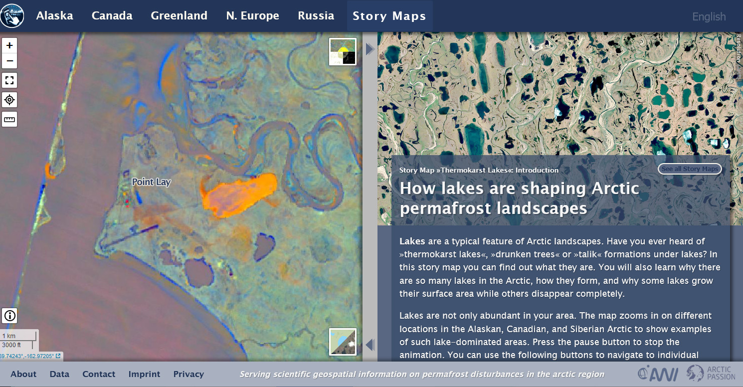
Figure 1: Screenshot of the Arctic Landscape EXplorer (ALEX) showing change data for Point Lay, Alaska (left) and a story map on thermokarst lakes (right).
ALEX is part of Arctic PASSION’s Permafrost Service: a satellite imagery-derived map product showing changes in permafrost thaw with 30 m resolution on the pan-Arctic scale with the ability to reliably detect and assess regional disturbances such as coastal erosion, lake drainage, thermokarst lake expansion, infrastructure expansion, retrogressive thaw slumps, tundra fires and fire scars, as well as the possibility to see change over time.
For more information on how the change data was derived, see the 'Data' section of the ALEX website. Besides a link to the PANGAEA data repository, where the dataset can be downloaded, you will also find instructions on how to use the change data as Web Map Service (WMS) in your application.
Learn more
Arctic PASSION’s Panarctic requirements-driven Permafrost Service.
Pan-Arctic Visualization of Landscape Change (2003-2022), Arctic PASSION Permafrost Service. PANGAEA, https://doi.org/10.1594/PANGAEA.964814
Contact
Guido Grosse (AWI), guido.grosse@awi.de
Tillmann Lübker (AWI), tillmann.luebker@awi.de
Ingmar Nitze (AWI), ingmar.nitze@awi.de
Reference
Canadian Geographic (2018). The big thaw. Arctic permafrost is thawing. What does that mean for the North — and the rest of us? Available on: The big thaw | Canadian